


Marine++ app for iPhone and iPad
Developer: Ewoud Wijma
First release : 27 Jul 2014
App size: 39.86 Mb
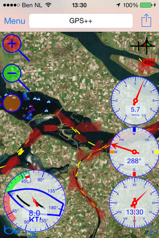
Marine++ tracks sailing trips and navigates from buoy to buoy and is a free app with additional ‘Packs’ (In-App-Purchases). Marine++ is a navigation app where everything comes together: maps in the colors you like, Buoys, Ships, Local Weather, Tide predictions, Completed Tracks or Routes. If you have a file with buoys or other nautical data, you can download it in Marine++!
The Free app places you on the map. for instance OpenSeaMap. The Marine Pack follows you, leads you, put buoys, local weather and tide predictions on the map. The AIS Pack put ships on the map. With the Dutch Waterway Subscription you subscribe to up-to-date buoys on Dutch waterways.
Marine++ supports the Plastic Soup Foundation. For every Pack you buy, Marine++ makes a contribution to the Plastic Soup Foundation!
FREE APP
● One app for both iPhone and iPad.
● OpenSeaMap and Bing Road and Aerial Maps.
● Tracks are created automatically, no start or stop button.
● Share tracks to e-Mail, Twitter and Facebook.
● Automatic caching of maps for off-line usage.
● Choice between north on top or direction on top.
● Fix center point on any place on the map.
● Compass course if speed is 0, GPS course if speed > 0.
● Select day and night style.
MARINE PACK
● Load buoys files. From Nautin or Escaut or manually import.
● Transform waypoints into marine buoys.
● Connect buoys together.
● Wind instrument showing true and apparent wind.
● Local Weather North-west Europe.
● Dutch Tide predictions.
● Dutch Depth estimations.
● Alarm if approaching buoys.
● Get access to all your completed tracks.
● Mile- and timestones on tracks.
● Merge, delete and export tracks.
● Track Analyser shows speed and depth.
● Enter a destination using buoys, street or city names.
● Integration of MapBox maps.
● Automatic routing based on available routes and tracks.
● Go to routes and points.
● Navigate using distance, duration and direction instruments.
● Import and export from kml, loc and gpx files.
AIS PACK
● Show position, ship and instrument data send by Wifi-enabled AIS device on the map. Also for iPad’s without 3G/GPS.
● Recognize your friends: Ships of friends are marked and yoy can contact them directly.
● Wind instrument displays wind, speed and depth data, if on-board-instruments are connected to the AIS-device.
DUTCH WATERWAYS SUBSCRIPTION
● Up-to-date buoys from WCIKaartenNederland.
● More then 10.000 buoys of Netherlands coastal waters and adjacent lakes and estuaries and adjacent German and Belgium buoys.
● Buoys are shown with their shape, colors, signs and lights.
● The subscription includes the following functionality of the Marine Pack: Warning approaching buoys, connecting buoys, duration and wind instrument.
MARINE WEEK SUBSCRIPTION
● Access to the Marine Pack and AIS Pack for a week.
Make sure that you use the most recent version of buoy and depth files. Even if you use the latest version available, this is still no guarantee that what you see on the map is the real life situation. Changes to buoys and their positions are made continuously and depths will also change continuously and not every depth position is covered. Marine++ is only a navigational aid, not a replacement for navigational knowledge. You remain responsible for navigation on your ship.
Continued use of GPS running in background mode can seriously impact battery life.
SOCIAL
● www.facebook.com/gpsplusplus
● www.twitter.com/gpsplusplus
● www.gpsplusplus.com/marine
● [email protected]